It took me a while to work that out.
The other Paragon rides in this series are all expeditions — four in the morning, everything in the pack, a whole day gone and legs that would not work properly the next one. Peavine. Dog Valley. Over Mt. Rose to the lake and back. Those are the ones you tell people about.
But they were not what I did most. What I did most was this: a little over twenty miles, out the door and back, a couple of hours, some of it on pavement and some of it on rock and some of it beside running water. Before a shift or after one.
It had everything in it and it never once broke me.
Where the idea came from
I was a lifeguard. Part of that job was getting the pool right before anybody saw it, which meant a skimmer and a hose at five in the morning with the whole place to myself.
I had a yellow Sports Walkman — the waterproof-ish one, the shape of a bar of soap — and I would put Midnight Oil on and go into the zone with the net, and every so often I would look up and west.
From up there you can see the whole western edge of the valley. And there is a notch in it, a canyon cut back into the hills where the ground goes from brown to something darker, and I looked at that thing for weeks before it occurred to me that I could simply go and find out what was in it.
That is the entire origin of most of what I did in those years. Look at something for long enough from a job, then go.
The ride before the ride
Thirty to forty-five minutes of town before you touch dirt, and I want to be clear that this counted. It was not commuting. It was the first act.
Out of the house, down through downtown, along the strip — cruising it, at whatever hour, past the marquees and the valet stands and the people either starting their day or refusing to end the previous one. Reno at six in the morning and Reno at six in the evening are two different cities and I got both.
Then down to the river.
And the Truckee in early summer is one of the genuinely beautiful things in that town. It comes out of Tahoe cold and fast and green, and there is a path along it, and for a couple of miles you are on a river in a desert with cottonwoods over you and the traffic somewhere else.
West along the river trail. Up through Idlewild. Over to Mayberry, then Caughlin Ranch, and then up through the nice houses.
The nice houses
They were very nice. Big lots up against the hill, west-facing, the kind of place where the driveway is longer than the apartment I was living in.
I rode through them a couple of times a month for years and I will not pretend I did not think about it. I was at East 6th and Valley, which was a different kind of Reno entirely — the kind with a lot of neon and not much lawn.
They were also new. The Caughlin family sold the ranch land in 1984 — a spread that had run from the Truckee up to Skyline since the 1870s — and the development went up on it after that. So when I rode through, those houses were about eight years old and the ditch behind them was a hundred and twelve.
But here is what riding a bike through a neighborhood like that at half past five in the morning gets you. You are the only one outside. Nobody in those houses is about to spend two hours in a canyon.
And then the trailhead, which at the time was not a trailhead. It was a pullout. There was no sign, no parking lot, no restroom, no map on a board. There was a place where the pavement gave up and a track went on, and you had to already know.
I gather it is quite developed now.
Rock, and then water
Hunter Creek starts hot and open. Sage, decomposed granite, no shade, the sun already working on you if it is the afternoon version of this ride. The track is loose in places and cut down to bedrock in others, and there is real technical ground on it — enough to make you pay attention, enough to make you pick a line.
Which is the balance of this ride, and why I kept coming back. The creek will take everything you have if you let it. But it will not take more than you have, which the big rides absolutely will.
You could get destroyed up there and still function afterward. Some of those other rides could genuinely break you.
And then you climb into the sound of water.
Here is what a desert canyon with a creek in it does to you. You hear it before you have any business hearing it — you are still in sagebrush, still in dust, and there is running water somewhere below and to your left, and then the vegetation changes over in about a hundred meters and you are in cottonwood and willow and it is ten degrees cooler and everything smells green.
There is a waterfall further up, about thirty feet of it. I made it there a few times, though usually on foot, because hiking in cycling cleats is its own special stupidity and I did it anyway.
The gauge
And then there is a small building beside the creek that has no business being there.
It is built like a bomb shelter. Squat, thick, government-issue, with hoses and conduit coming out of it and a cable strung across the creek with a little trolley hanging off it. There is an enameled staff plate down in the water, a ruler for reading the level. And somewhere on it, USGS.
I knew roughly what it was. I had seen these things before and I had a general idea — somebody measures how much water is going past, and the number goes somewhere.
What I could not work out was this one.
USGS 10347600 — HUNTER CK NR RENO, NV
Still there. Still running. It reported 4 cubic feet per second on the first of September this year.
Elevation 4,880 feet. Drainage area 11.5 square miles. It has peak-flow measurements on record back to January 1962 — which means when I stopped there in the nineties, that box had already been at it for thirty years.
It is a Federal Priority Streamgage. Real-time discharge, gage height, water temperature, free to anybody, no login.
And in the nineties none of that was true. Continuous telemetry at that station only starts in October 2002. When I was standing there wondering who reads this, the answer was: a person. In a truck. Who drove out and did it by hand.
Because look at where it is. That creek is not the Colorado. In high summer there is barely anything in it — a trickle over rock, some pools, long stretches you could step across without noticing you had. Some years less than that.
So why would you build a bunker on it?
Who decides that this particular creek, in this particular canyon, out of the hundred other draws coming off that range, is worth a permanent instrument and somebody's time forever?
I had been reading Edward Abbey by then, so I had a general disposition toward government works in the desert, and it was not a warm one. But I could not make this one fit the pattern. There was nothing being dammed here, nothing diverted, nobody making money. Just a box, on a creek that sometimes wasn't one, counting.
I thought it was interesting and then I got back on the bike, because I was twenty-something and I had about ninety minutes left and there is a limit to how long you stand in a canyon thinking about federal hydrology.
I did not know I would spend my life doing this. I needed to get outside and ride my bicycle.
A little past the gauge there is a line where the map changes color. Mount Rose Wilderness — thirty-one thousand acres, drawn in December 1989, which is to say drawn by people in a room not long before I first rode up there. No bikes past it.
So that was the turnaround. Not a summit, not a lake, not an achievement. A line somebody drew.
I would stand there a minute, and then I would point the bike downhill.
Bomb it
The descent off Hunter Creek is the reward and it is short and it is very good. Everything you crawled up you get back in a few minutes, loose over hardpack, brakes covered, the creek noise dropping away behind you and the whole valley opening out in front.
And then you get on the Ditch, and the ride changes character completely.
It goes flat. Not gently — flat. Railroad-grade flat. You come off a mountain track and onto a bench cut into the hillside that just runs, contouring west, with water in it beside you.
Why it is that flat
The Steamboat Ditch is thirty-four miles long. It takes water off the Truckee near the California line and carries it around the west side of Reno to Steamboat Creek in the south valley.
The Truckee & Steamboat Irrigating Canal Company formed in 1877. The ditch was dug by Chinese laborers — two years and about forty thousand dollars — and opened on 1 July 1880.
White laborers in the area were angry about the hiring and announced they would drive the Chinese workers out by force. The ditch was built anyway.
Its grade is roughly one in six hundred and sixty. Somebody walked that hillside with a level in 1878 and found a line that falls about an inch every fifty feet, and held it for thirty-four miles.
It still runs. It still delivers water to about five hundred properties.
I did not know any of that at the time. I thought it was a nice flat trail with water in it.
And it is a completely different pleasure from the climbing. On Peavine or Mt. Rose you are frequently not in control — the mountain has opinions and you are negotiating. On the Ditch you are in total control and you can move. It winds, it contours, it never climbs, and you can carry real speed for miles with the whole Truckee Meadows laid out below you on the left.
Downtown from up there looks small and tidy and rather nice, which it is not. All the grit sands off at that distance. You can pick out the casinos, and if you know where to look you can find the roof you were standing on at five that morning with a net in your hand.
And across the valley, north, sitting there the whole time: Peavine.
Riding one mountain while looking at the other one. That never stopped being good.
Sunrises out there were remarkable. So were the sunsets. It was, to use the assessment I gave it at the time, all cool.
What else is out there
You still had to pay attention. There were rattlesnakes to hop — not a den, nothing like the Pah Rah, just the ordinary business of a warm afternoon in Nevada. And a couple of genuine standoffs with coyotes, which is a thing that happens when you are the only person on a trail and something with better local knowledge than you decides to hold its ground for a moment.
Otherwise: the occasional other cyclist, people on horseback, a runner, birdwatchers with binoculars looking at something I never identified.
Water is life, and the water brings life. That is not a metaphor out there, it is just an observation. Everything alive on that hillside is alive within about thirty feet of that ditch.
Access on the Ditch was contested then and I gather still is. It runs behind a lot of expensive property, and there were stories in the paper — landowners, barbed wire strung across the trail, the whole argument about who a right of way belongs to when the houses arrived after the ditch did.
I never ran into any of it myself. But you knew about it, and you rode it slightly aware that somebody somewhere considered you a problem.
You can just know that it does
The Ditch runs west until it meets a ridge that is in the way, and rather than go around it, whoever built this thing went through.
Hole in the Wall. The water goes into the hill on one side and comes out on the other, and that is the end of the trail as far as bikes are concerned.
There is a steep track up and over the ridge if you want to go and look at the far portal. I did it a few times. And then I stopped doing it, because the climb is not worth the payoff, and because the water does come out the other side.
You can just know that it does.
I was more comfortable with that sentence at twenty-something than I am now. Somewhere in the intervening thirty years I turned into a person who goes back and re-runs an entire analysis because one number moved in the third decimal place, and there is a version of me that would now climb the ridge on principle.
But the kid on the ditch trail was right. Water goes in one side of a hill and comes out the other. Some things you can just know.
On top of that ridge above the Hole, which I climbed several times and then stopped climbing, there is a fifty-foot concrete arrow lying on the ground.
It is a navigation marker from the Transcontinental Airway System, funded by Congress in 1923. Concrete arrows painted yellow, every ten miles from New York to San Francisco, each with a fifty-foot steel tower and a rotating gas beacon on it, so that airmail pilots in open-cockpit biplanes could fly at night by going from light to light.
The Reno Evening Gazette of 31 July 1928 describes about thirty men dragging that steel tower across the Steamboat Ditch and hauling it up the hill above Mogul with tractors.
Across the same ditch. Up the same hill. The towers were mostly scrapped for metal during the war; the arrows stayed where they were.
I rode past it dozens of times over several years and had no idea it was up there.
Down to the water and back into town
From the Hole you can turn around and take the ditch back the way you came, which I often did.
Or you drop off the side.
Down toward Mayberry Park there are switchbacks — proper zigzags, some technical bits, tight and quick and a very fun way to lose a couple of hundred feet. It spits you out at the bottom, at a Patagonia distribution warehouse, which I am fairly sure was not there then and which I will come back to.
Then the river again.
And this is the best twenty minutes of the day. You stop at the park. You are salted and dusty and your arms are shaking slightly from the descent, and there is the Truckee going past, cold, and there is a scene — kayakers working a wave, or people drinking beer on the bank in the late sun, and quite often both at once, which is Reno in one image.
Then up onto West 4th and east into town.
And from there it depended entirely. Straight to work, if it was the morning version — get the shift in, and then usually swim a mile in the pool afterward, which in retrospect was a lot of exercise for a person also holding down a job. Or home to the house. Or across the street to Bavarian World for a German beer, which had its own gravity.
All of it available. That was the point of the ride.
What it actually was
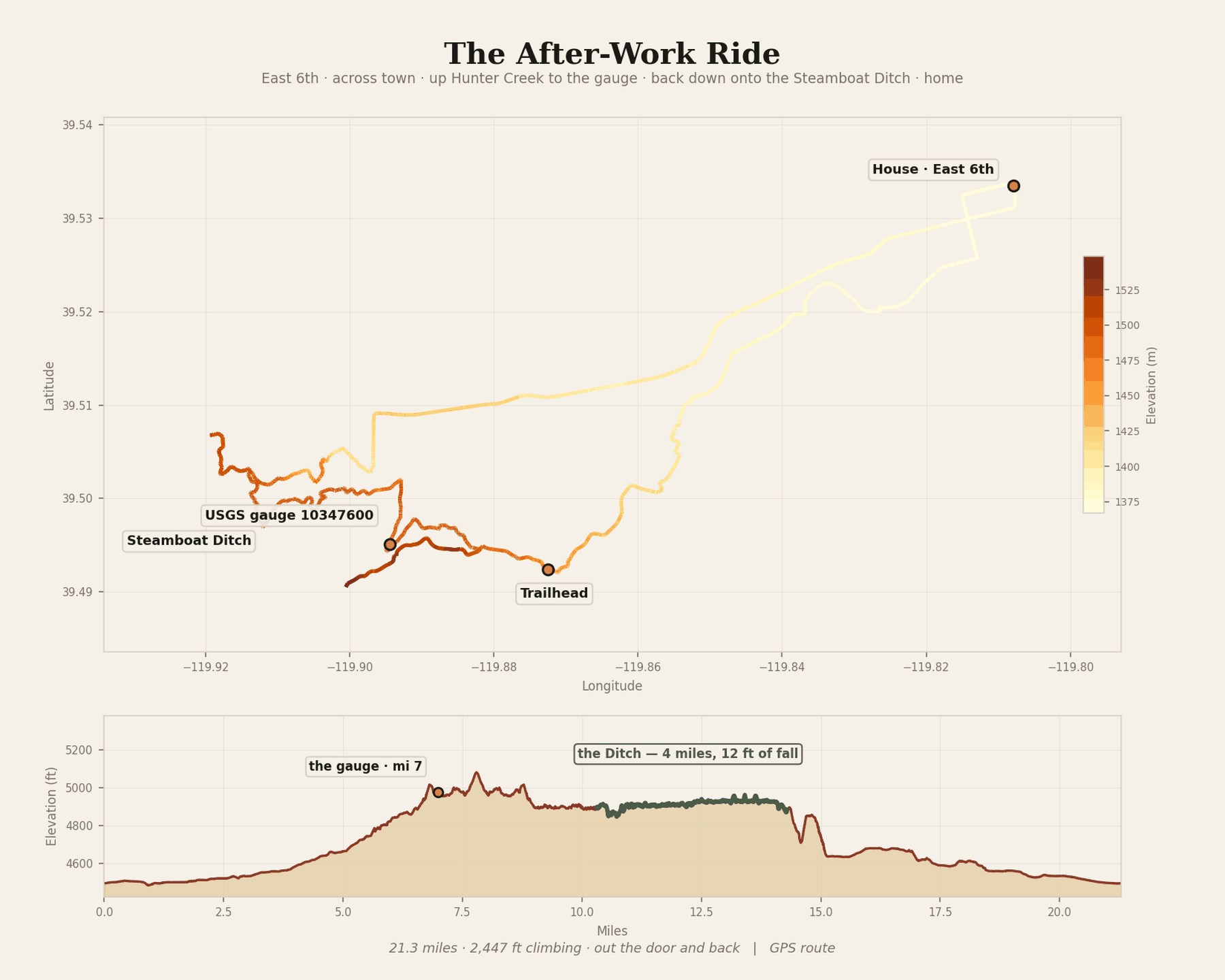
I never knew the numbers. Drawing it properly, decades later:
The numbers
21.3 miles. 2,447 feet of climbing. Low point 4,485 feet at the river, high point 5,081 just above the gauge.
The gauge at mile 7. The Ditch from mile 10 to mile 14. Home by mile 21.
And the GPS puts the route within ten meters of USGS 10347600, three separate times.
Two to three hours, typically. Longer if you went exploring, or had a flat.
Twenty-one miles and two and a half thousand feet, as the easy one. I did not think of it as a big ride at the time and I am not sure I was right about that.
Why this one, and not the mountain
A couple of times a month. Sometimes weekly. Sometimes more, because it was so easy to get to.
Mostly spring, into summer and fall. Not much in winter. And heavily in spring specifically, because the big rides were still under snow — which is its own local calendar. People up there read the snow coming off Peavine the way farmers read a frost date. When the mountain clears, the season starts. Until then you ride the low country.
I went alone, essentially always. Not many people I knew could keep up, or wanted to be out that early, or both.
There was a guy in valet who was, by common agreement, too crazy. He had been barred from a downhill event at Mammoth for being too crazy, which is a difficult standard to fail.
He is the one who told me about half these trails.
He went on to kayak rivers in Patagonia that had never been run by anybody. Which is why I laugh at that warehouse at the bottom of the switchbacks.
And I could not tell you about one specific day out there. That is the honest answer. The big rides I can walk you through hour by hour — Dog Valley, Mt. Rose, the whole Peavine loop. This one has blurred into a single composite ride made of forty or fifty of them, with variations: different lines, different roads, a new bit of trail I had not tried, whether I turned at the Hole or dropped to Mayberry.
That is what a place you go to regularly does. It stops being an occasion and becomes a shape.
If I went back tomorrow I suspect it would look different — more houses, a real trailhead, signs, a map on a board. But I think I would know it immediately anyway, and not by sight. By the sound the gravel makes under a mountain bike tire on that particular hillside.
Postscript, for what it is worth
I do this for a living now. I am a GIS analyst. I build things that pull hydrological data and satellite imagery and turn them into something a person can read.
Two weeks ago I spent several days working out how badly an aspen grove on Peavine had burned, from eight hundred miles away, and then re-doing the whole thing because a number that had no business changing had changed.
And I pull USGS gauge data constantly. Hundreds of stations. It arrives as JSON, instantly, free, from anywhere.
10347600 is still my favorite one. Partly because you have to work to get up there. Mostly because of what it took me a long time to understand about it — that the reason to put an instrument on a creek that is sometimes dry is precisely that it is sometimes dry. The years it runs and the years it doesn't are the whole question. You cannot know that without somebody having stood there for sixty years counting.
Somebody made that decision in 1962. I rode past the result of it in the nineties and thought it was interesting and rode home.
Anyway. Twenty-one miles, a couple of hours, and back in time for a shift.
Still a good workout.
Not Every Ride Has to Kill You
Hunter Creek & the Steamboat Ditch · Reno, 1990s